COL DE SAGNES
COL DE SAGNES
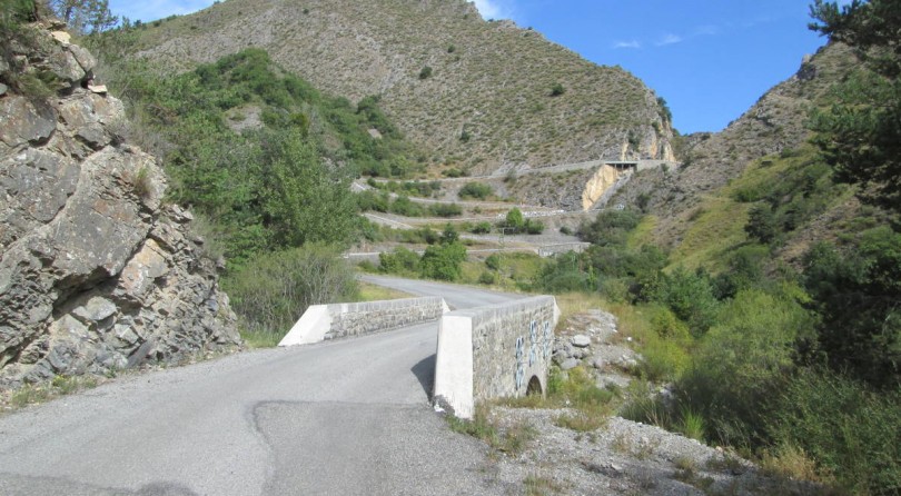
The Col des Sagnes hardly ends up on the itinerant radars of those visiting the area that extends a few kilometers south of Gap, but the reason is due to the fact that in the proximity there are a large number of far more famous driving roads. However, reality is that even this hill road, despite reaching just 1,189 meters above sea level, has had its say in competitions such as the Monte-Carlo Rally and the Tour de France. And when you find these two names in your palmares it is easy to guess that there are curves and a landscape that is anything but to be overlooked such as that between Gigors and Bayons, the two towns identified as the beginning and conclusion of the stretch of about 20 kilometers requiring almost one hour drive.

Location: Gigors – Bayons
Type: twisty road
Length: 20 km
Elevation: 1.189 m
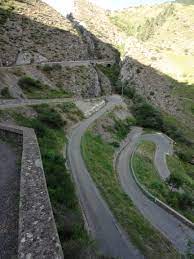
The road is mostly narrow, but it almost always offers good visibility on the opposite direction. As this is a low-altitude hill, expect a thin asphalt snake that creeps into the middle of the valley, with unobtrusive vegetation and an almost lunar sensation offered by the lack of landmarks. The southern side is undoubtedly the most engaging, especially once you reach Les Tourniquets de Bayons, which with its bridges and stone walls that anticipate a splendid view over four hairpin bends piled one on top of the other, reveal one of the most spectacular and characteristic spot of the region.
Photos credits go to their respective owners


Related tags to article